| Greg Rice - Travel_Man | ||||||||||||||||||||
|
Weird Stuff BBG October 4, 2017 |
||||||||||||||||||||
| Fort Lauderdale, FL To Allen, TX | ||||||||||||||||||||
|
This Ride To Honor All Who Lost Their Lives In The Las Vegas Massacre |
||||||||||||||||||||
|
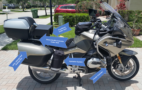
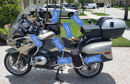
I am going to attempt my 44th BBG on my way to the IBA Big As Texas Party October 4, 2017. I am going to add bonus stops to my route that I found on Roadside America's website. All of the locations are less than 5 miles off the highway and I am hoping to make as many bonus stops as possible in the 24 hour period while riding a BBG ( Bun burner Gold, 1500+ miles in less than 24 hours ). I am not sure how many bonus stops I will be able to make and still complete my BBG so I created a long list to work off of during my ride. Below are interactive maps of my route, Spotwalla location and weather. The below locations are possible bonus stops on my ride to Allen, TX.
|
||||||||||||||||||||
 |
 |
|||||||||||||||||||
|
|
||||||||||||||||||||
|
Interactive Maps |
||||||||||||||||||||
|
The Google route map and the Spotwalla tracking map allow you to zoom in and out using the + and - buttons in the bottom right of the maps and you can drag the map with a mouse. You can also zoom in and out of the maps with a mouse that has a wheel. They show my planned route ( Google Maps ) and below that map is a map of my current location with the use of a SPOT satellite tracking device and Spotwalla.com ( thanks Jason Jonas ). The last map below is a national weather radar map where you can see the weather along our route. I use the following states DOT websites for traffic and construction information during our ride planning. If I see large scale construction zones I will mark them with custom POI's in my GPS's so I get alerted when I am getting close to them. This information helps me understand why traffic may be slow in those areas.
| ||||||||||||||||||||